Friday, September 21, 2012

Sick day: Midweek foray to 50-40 Peak

With a sunny and hot high pressure system permanently parked over much of Vancouver Island this month, it was only a matter of time before something was going to give. In my case, an invitation to hike 50-40 Peak from a local hiking group was simply too great an opportunity to pass up, even if it meant a ditching an already understaffed office on a Thursday. Some days are just too nice to spend inside. Besides, I really was in need of a little something the Japanese call shinrin-yoku.


 Forest bathing, as it's translated in English, basically involves visiting a forest for relaxation and recreation. The bathing component refers to the human body's supposed immersion in a wealth of atmospheric substances emitted by trees and foliage known as phytoncides.

Apparently, the effects of bathing in the forest air showed some positive effects in enough studies that, in the early eighties, the Forest Agency of Japan recommended regular jaunts through the forest as an important part of a healthy lifestyle. Since then, it's become a recognized relaxation and/or stress management activity in Japan and other parts of the world.

Breaking through the treeline.
Even though people in Canada have been hanging out in the woods for all sorts of worthwhile reasons since day one, shinrin-yoku made the headlines when it was featured in the Globe and Mail newspaper in May 2012.


The lower slopes 50-40 Peak's Cobalt Lake Route, accessed at the 10-kilometre mark of Marion Mainline off Highway 4, offered some ideal forest bathing terrain. After a quick skip along a steep and steady  huckleberry-lined trail through teen-aged second-growth forest, the trail sides a creek that runs through an impressive stand of towering yellow cedars and hemlocks. Don't let summit fever prevent you from taking a moment to breathe in those phytoncides.

The big timber eventually gives way to sub-alpine vegetation and the occasional rocky outcrop with great views across the valley to Cat's Ears, Triple Peak, Pogo Peak the Pacific Ocean and countless other Vancouver Island high points.


Attainable in only 90 minutes at a comfortable pace, Cobalt Lake is a worthwhile goal in its own right. Great views, a comfortable lunch spot and a chance to play in the September snow. Only complaint was the bugs who realized we'd arrived in the neighbourhood. by the time I'd unwrapped my sandwich.

Cobalt Lake in September.
Above Cobalt Lake, the trail climbs through a last thicket of forest to reach a wonderful ridge with more great views towards the mountains of Strathcona Park and beyond. Form here it was a matter of negotiating our way through a series of small scree fields and gullies to the summit ridge. The trail isn't always obvious, but a good look around should get you back on track. On the way down, we got sucked down a narrow and steep gully that required plenty of root swinging between footholds. The terrain above Cobalt offers something a little more than any old walk in the woods and the alpine flower show made it especially worthwhile.


The views from the top are spectacular but bright sunshine and temperatures easily approaching 30C on the summit ridge, it wasn't long before I found myself wishing for another dose of shinrin-yoku in the cool moist forest below.

Nootka Lupine


Thursday, August 30, 2012

'A temple not made by hands'

The last official weekend of August saw fine weather and ideal snow conditions for a long-awaited attempt to climb the northernmost of the great volcanoes that punctuate the United States' West Coast.

The omnipresent cone of Mount Baker's Grant Peak has a tendency to creep into the landscape at the most unlikely of moments, casting a long shadow over the aspirations of island-bound mountaineers across the Salish Sea. Looming high above the Fraser Valley's coastal plain, the mountain's glaciated summit often appears detached from the very earth through which it shot skyward about 15,000 years ago. How that vision is changed when cresting through the treeline at the end of the well-groomed Heliotrope Trail.

Aside from the walk-up approach, well-developed infrastructure and need for parking permits, little has changed since Edmund T. Coleman led the first-known ascent of the mountain back in 1868. Back then he recalled being "solemnly impressed" by "the tender beauty of the wild flowers blooming around" and "the grandeur of the rocky peaks shooting up into the deep blue vault." It's as though, he wrote, "we were in a temple not made by hands."

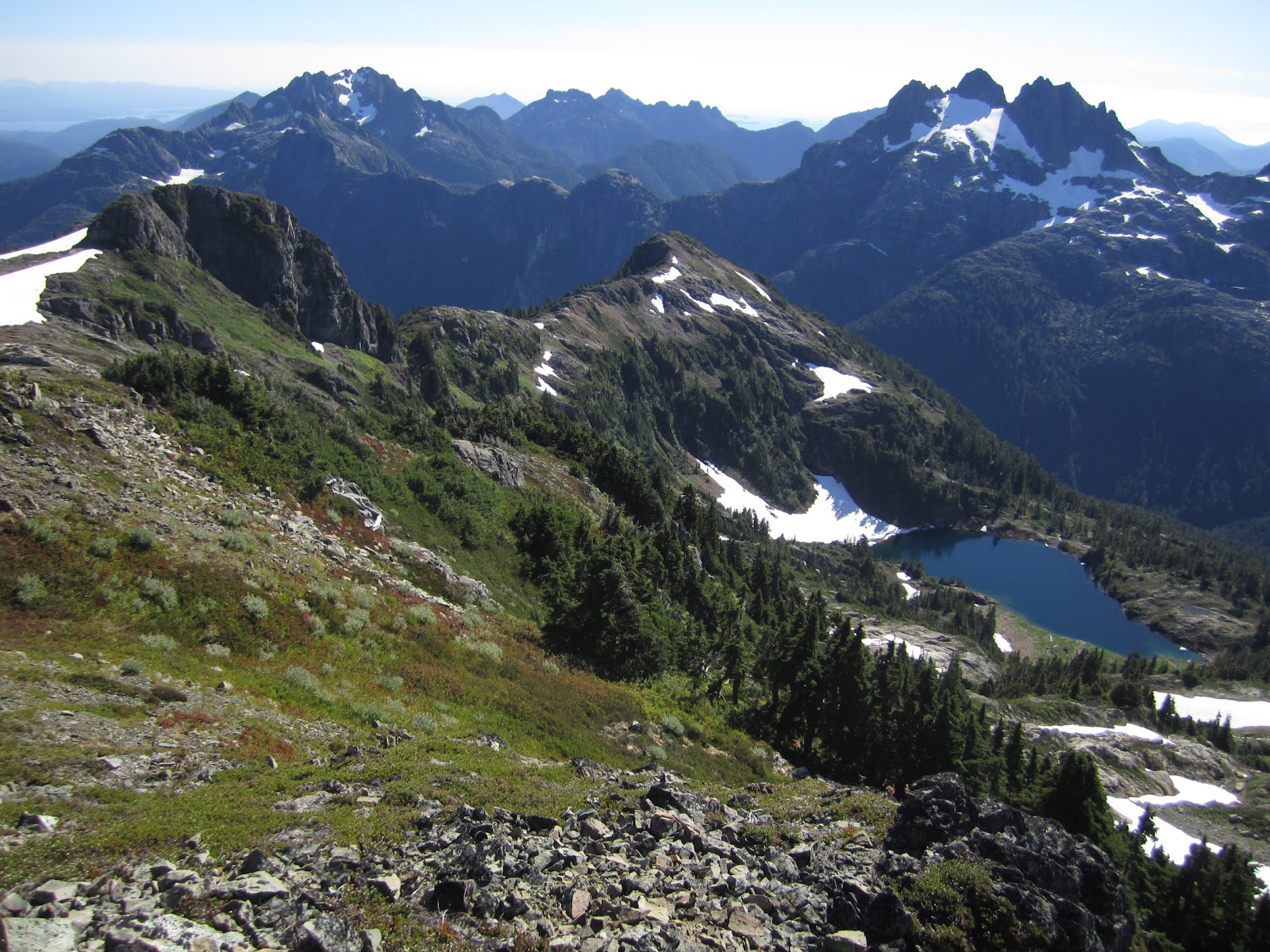
August wildflowers below Hogsback Camp
Mt. Baker's snow-covered dome rises towards the "deep blue vault"
Coleman and company may have been moved to "involuntary exclamations of praise" when he first caught sight of the peak but our group of three modern-day adventurers was happy enough to pitch camp and brew up some tea before nightfall at the first available site we could find at the Hogsback Camp (1,675m/5,500ft.).

The following day we awoke to the sounds of some intrepid climbers passing our tents making their way up to the summit along the boot-packed Coleman-Deming Route from the parking lot below. By 7 a.m. we were roped up and prepared for the quick 90-minute glacier walk to the impressive Gargoyle Camp (2,210m/7,250ft), appropriately named on account of the stunning panorama that beholds those fortunate enough one of the few spots of the melted out ridge.

Hanging out at Gargoyle Camp
A day of exploration on the glacier up to an elevation of 8,000 ft, a bit of reading and an afternoon nap led to some culinary experimentation that yielded an impressive concoction of couscous, bacon and tomato sauce. Appetites satiated, we hastened an early return to our tents for a fitful sleep as we incessant winds that battered our perch.

I was already awake and pretty psyched for the journey before us when my watch began to chime at 2:30 a.m.  One energy bar and a cup of tea later and the group were ready to join the distant parties who'd already set out from below to climb under a the starry and silent late-August sky.

Hot late-season weather had exposed most of the glacier's hazards
By this point in the journey, our party had amassed a small collection of USFS-issue blue compostable waste-collection bags. The bags are intended to replace a set of outhouses that used to be flown in and out of the area each climbing season. Whether a move towards better stewardship of a busy mountain playground or a budgetary cost-saving measure, it remains to be seen if the alpine innovation will be mentioned in the run-up to the November 2012 presidential election.

By day break, we'd succeeded in plodding our way around the series of exposed crevasses to reach the saddle, where two other groups had elected to spend what must have been a frigid and much more windier night than we'd endured. Up the pumice ridge, through the odour of sulpherous emissions, across the Roman Wall's booted track and along the great walk past the playing field-sized summit dome brought us to the summit pimple (3,285 m /10,778 ft) in fine form and without incident.

Monkeying around before sunset on day 2

Sources:

Mountaineering on the Pacific, by Edmund T. Coleman, Harper's New Monthly, November 1869

All photos courtesy Alan Bibby.


Friday, July 6, 2012

Don't think of a mountain!

It's great when a promising adventure can be found just down the road— no ferries, no shuttling around to pick everyone up and no need to even gas up the car.

Peter Levitt, SSI Zen Circle
A few weekends ago, the Salt Spring Island Zen Circle hosted a free Sunday morning silent retreat a few blocks from my house. I've been interested in Buddhism and intrigued by Zen ever since I picked up a neat little book called Zen Comics at a second-hand bookstore as a teenager. For several years, I dreamed of joining a monastery in Sri Lanka (orange robes) India (red robes) or Japan (black robes).

Sri Lankan monks wait for the bus
As I was trying to figure out which colour I liked best, I met the woman I'd eventually marry, got a real job and bought a house. The trappings of suffering may confine, but they're also quite comfortable. It's an unfortunate irony the busy people in life, who arguably have the most to learn from meditation, are often the ones who can't find time to "just sit".
 
When I spotted the event's simple black-and white photocopied flyer posted to a local sign board and realized I had no plans for that day, I figured my chance to get a sense of Zen life had finally arrived. Zen had finally tracked me down.

Despite a number of last-minute speed bumps ( my mom's fear I'd get hypnotized,  a late Saturday night with friends and enough yard work to occupy my mind for an eternity), I made it to the Ango Retreat a few minutes early for some Zen Meditation 101.

Ango Retreat, Salt Spring Island, B.C.
My Buddhist life had always been a private affair that I'd read about in books, practiced on especially challenging hikes or during lengthy public transit rides. During a trip to Daramshala in 2000, I was enlightened to learn I was most attracted to the philosophy's recurring themes of quest and escape, association with remote and often rugged landscapes, and Tibetan cuisine. I was nervous and afraid to join the group since it was only on a rare occasion that I'd ever speak about Buddhism, religion and spirituality with others, including Buddhist friends. As if being a spiritual fraud wasn't unsettling enough, I was unsure what I'd discover in the recesses of my own mind and certainly wasn't prepared to encounter whatever circumstances motivated others to join the group.

At about 7:45 a.m., a very friendly woman offered me a few tips on how to sit, breathe, clear my mind and handle the inevitable distractions that arise when sitting with one's eyes closed for 25 minutes. I was soon fluffing up my cushion at the edge of the yurt and the session began.

Finally, it was time to just sit.

Zen Comics

Saturday, June 16, 2012

Celebrating spring on Klitsa Mountain's north ridge

Thirty minutes to the west of Port Alberni begins a thick tangle of steep-sided peaks that channel Highway 4 to the open Pacific. Most see only a trickle of climbers throughout the season but a contingent of local mountain folk have charted several routes up the most prominent peaks.

Avalanche runout at the base of Klitsa Mountain's north aspect

Among those is the 1,639-metre (5,377-foot) Klitsa Mountain, whose summit and north ridge dominates the south west skyline as one drives along Sproat Lake. To the Hupacasath First Nation, the mountain has traditionally been called Kleetsa because of the white chalky appearance it maintains for most of the year. During an early June foray to the summit along the mountain's north ridge, the name didn't fail to disappoint.

Descending Klitsa's Great Gully

 Although closer than many of Vancouver Island's more well-known peaks, the area's many overlooked summits are still a pretty long trek for most south island resident. Throw in the need to catch a ferry over from Salt Spring Island and the benefits of overnight near the trail head become significant — even with 14-hours of daylight.

Our party of eight elected to camp out in a clearing along the Taylor River main logging road which traces the banks of the swift-flowing Taylor River. The head start gave us ample time to enjoy our surprisingly scenic "campsite"before hitting the trail at about 8 o'clock.

We travelled several hundred metres up a logging spur until the deteriorating road finally gave out at a washout. Although it had previously been possible to drive along much of the spur until the trailhead proper, it appears those days won't return anytime soon. To add insult to injury, it seems part of the forgotten spur suffered some pretty hefty avalanche damage.

After about a 45-minute stroll, the trail takes a sharp right and begins to climb alongside a stream through a picturesque old-growth hemlock forest. Some in our group spoke of rumours the area might be logged in the near future, an unfortunate prospect indeed.

The trail reaches the base of a gigantic north facing bowl. A chaotic scene of uprooted trees proved this is no place to hang around in avalanche season. With crampons cinched and harnesses secure just in case, our route followed a semi-steep narrow gully up hiker's left to the North ridge proper. Rain turned to sleet and sleet turned to rain as we crested the ridge and sat down for a well-deserved lunch.

Even in June, the ridge carried some impressive cornices but the snow conditions were ideal as our crew kicked steps towards the summit block. With only a few hundred metres to go, four of our party veered to the east to ascend the final summit block by way of a cozy looking gully that shot its way up the mountain's north eastern aspect.

Ascending Klitsa Mountain's north ridge
Reaching the clouds along Klitsa's north ridge
Towards the Jubilee Gully

The phenomenal views we'd come to take in were nowhere to be seen when we reached the top shortly after 2 p.m. It wasn't until we were preparing to make our descent via the Great Gully that the sun finally burned through the clouds and lit up the massive bowl at our feet. A welcome glissade/butt slide got us to the treeline double quick for the easy ramble back to our vehicles below
 
Down the Great Gully
For more pictures click here